
Retrofitting non-powered dams offers a more cost-effective and environmentally friendly path to grid decarbonization than constructing entirely new impoundments. As the United States intensifies its pursuit of a cleaner and more resilient electrical grid, the role of hydropower has transitioned from a traditional baseload provider to a dynamic and flexible backbone for renewable integration. This evolution requires a sophisticated understanding of water resources, which is currently facilitated by HydroSource, the nation’s definitive energy-water digital infrastructure. Developed and managed by the Oak Ridge National Laboratory and sponsored by the Department of Energy, this platform serves as a centralized repository designed to eliminate the historical fragmentation of water data across various federal and regional agencies. By synthesizing disparate information from entities like the Federal Energy Regulatory Commission and the Geological Survey, it provides a unified geospatial product that is indispensable for modern energy system evaluations. The mission is clear: to equip energy modelers, policy analysts, and researchers with the high-quality, standardized information needed to navigate the complex relationship between national hydrology and power generation.
Adhering to FAIR data principles—ensuring that information is findable, accessible, interoperable, and reusable—remains a cornerstone of the platform’s operations. By utilizing persistent digital object identifiers and open-access distribution models, the project has successfully removed traditional licensing barriers that once hindered the academic community and private researchers alike. This commitment to transparency fosters a collaborative environment where national energy research and development can flourish without the constraints of siloed information. The infrastructure is built on a modular technical architecture, meaning it captures various aspects of the hydropower life cycle in discrete domains, from physical attributes and hydrological contexts to regulatory statuses. This organization ensures that each dataset undergoes rigorous validation and spatial normalization before being released to the public. As of 2026, the platform continues to expand its reach, providing a digital foundation that supports climate resilience planning and macroscale energy analysis across the entire country, including its territories and coastal regions.
Comprehensive Cataloging of Existing Hydropower Assets
The Existing Hydropower Assets database serves as the authoritative census for every operational hydroelectric facility across the United States, providing a necessary baseline for national energy planning. This module is updated annually to reflect the current state of the industry, offering insights that range from massive federally owned dams to small-scale private installations. It functions at two distinct levels: the high-level plant database and the granular unit database, ensuring that stakeholders have access to both macro and micro perspectives. At the plant level, the database tracks critical operational metrics including nameplate capacity, net generation time series, and hydraulic head measurements. It also meticulously identifies the regulatory jurisdiction of each facility, distinguishing between those authorized by federal mandates and those operating under specific licenses or exemptions. This data allows for a comprehensive understanding of how various plants contribute to regional energy needs and how they might be impacted by shifting regulatory landscapes.
The unit-level data provides engineering specifics for individual turbine-generator sets within these powerhouses, offering a level of detail that is indispensable for the modernization of the aging domestic fleet. By tracking turbine designs such as Francis, Kaplan, or Pelton units, along with their original installation and refurbishment dates, the platform enables engineers to model turbine efficiency and assess the risk of cavitation with high precision. This granular focus is particularly relevant as many facilities approach the end of their design lives and require significant upgrades to remain competitive in a modern energy market. Understanding the rated discharge capacities and engineering constraints of each unit helps planners prioritize investments where they will have the most impact on grid stability and energy output. Furthermore, this information supports the broader industry goal of maximizing the performance of existing infrastructure, ensuring that every drop of water used for power generation is utilized as efficiently as possible during this critical period of energy transition.
Evaluating the Viability of Non-Powered Dams and Assessing Their Potential for Hydroelectric Power Conversion
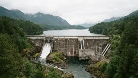
A significant portion of national research infrastructure is now dedicated to quantifying the untapped hydropower potential inherent in the thousands of existing structures that do not currently generate electricity. Of the roughly 92,000 dams recorded in the national inventory, fewer than three percent are equipped with powerhouses, leaving a vast amount of infrastructure that could be repurposed for clean energy production. Because the primary civil works and impoundments are already in place, these projects offer a streamlined path to development that avoids many of the environmental and financial hurdles associated with building new dams from scratch. The focus on non-powered dams represents a strategic shift toward low-impact development, where the goal is to extract additional value from existing human-made changes to the landscape. This approach aligns with modern conservation priorities while providing a scalable solution for increasing renewable energy capacity in regions where water resources are already managed for navigation, irrigation, or flood control.
To facilitate the identification of these opportunities, the platform provides the Non-Powered Dam Custom Analysis and Taxonomy Tool, an interactive geospatial system that allows developers to filter potential sites based on a variety of technical and environmental criteria. Users can assess hydraulic head, proximity to existing electrical transmission lines, and local environmental sensitivities to determine which sites are the most viable for retrofitting. This capability allows stakeholders to save significant capital during the early planning and screening phases by eliminating infeasible sites before expensive site-specific studies are commissioned. By providing a transparent and data-driven way to evaluate these resources, the tool empowers both public and private entities to explore hydropower expansion in a way that is scientifically rigorous and environmentally responsible. The integration of this taxonomy tool into the broader research infrastructure ensures that the development of non-powered dams remains a key pillar of the national strategy to modernize water-based energy systems.
Expanding Resources through New Stream-Reach Development
The New Stream-Reach Development module addresses the potential for hydropower growth in undeveloped river segments by utilizing advanced modeling techniques to identify low-impact opportunities. This research focuses on river reaches that have not been dammed but possess the hydrological characteristics necessary to support power generation. By integrating synthetic stream networks with regional runoff data, the module identifies segments where flow and elevation drops could theoretically sustain energy production without necessitating large-scale impoundments. Crucially, the assessment process strictly excludes federally protected areas, such as national parks and wild and scenic rivers, ensuring that any identified potential is compatible with national conservation goals. This balanced approach allows for the discovery of new energy sources while maintaining the ecological integrity of the nation’s most sensitive watersheds. It reflects a modern understanding of hydropower that prioritizes environmental stewardship as much as energy output.
The identification of these reaches is supported by regional analyses that take into account the unique hydrological and environmental constraints of different parts of the country. For example, in the Pacific Northwest, the focus might be on maintaining fish passage and river connectivity, while in the Southeast, the emphasis could be on managing high-variability flow patterns. The data provided through the New Stream-Reach Development module allow planners to visualize where new, small-scale technologies could be implemented to contribute to local microgrids or regional energy supplies. This focus on “low-head” and “run-of-river” technologies suggests a future where hydropower is integrated more seamlessly into natural river systems rather than dominating them. By providing this geospatial intelligence, the platform ensures that the next generation of hydropower projects will be smaller, more modular, and significantly more sensitive to the aquatic environments they inhabit, marking a clear departure from the massive dam-building era of the mid-twentieth century.
Comprehensive Reanalysis of Historical Streamflow Patterns Utilizing Advanced Dayflow Modeling Frameworks
Predicting the actual output of the national hydropower fleet requires a sophisticated understanding of hydrologic variability, which is the primary focus of the Dayflow project. This large-scale streamflow reanalysis effort models discharge across approximately 2.7 million stream reaches in the contiguous United States, providing a high-resolution look at how water moves through the landscape. By utilizing the Variable Infiltration Capacity land surface model and the Routing Application for Parallel Computation of Discharge, Dayflow generates hourly estimates that are essential for short-term forecasting and long-term climate assessments. This level of detail is necessary because hydropower generation is fundamentally tied to the timing and volume of river flows, which are increasingly influenced by changing weather patterns. The ability to model these patterns with such high precision allows grid operators and plant managers to better anticipate periods of high generation and plan for potential droughts that could limit power availability.
A critical feature of the Dayflow project is the distinction it makes between naturalized streamflow and assimilated streamflow, the latter of which accounts for human regulation and dam operations. Naturalized flow represents the hydrology of a watershed as it would exist without human intervention, providing a baseline for ecological studies and climate research. In contrast, assimilated flow reflects the actual conditions of managed river systems, incorporating the effects of reservoir storage and regulated releases. This dual perspective is vital for researchers who need to quantify the exact impact of human activities on national watersheds and understand how existing infrastructure alters natural cycles. As the nation faces more frequent extreme weather events, the insights provided by Dayflow are becoming increasingly important for ensuring the resilience of both the energy grid and the ecosystems that depend on consistent water management. The project effectively bridges the gap between atmospheric science and power systems engineering, creating a more holistic view of the energy-water nexus.
Documenting Environmental Mitigation and Aquatic Care
Beyond energy production, the platform serves as a vital repository for documenting the environmental impact and mitigation efforts undertaken by the hydropower industry. Federal regulations mandate that operators implement specific measures to protect aquatic ecosystems, and tracking these requirements provides a transparent record of the industry’s ecological footprint. This database includes information on specialized infrastructure such as fish ladders, elevators, and nature-like bypasses designed to maintain riverine connectivity for migratory species. By cataloging the design and operational efficiency of these systems, the research infrastructure helps regulators and scientists identify which technologies are most effective at different types of facilities. This transparency is essential for building public trust and ensuring that hydropower remains a socially and environmentally acceptable component of the national energy mix.
In addition to physical passage systems, the platform monitors dissolved oxygen enhancement technologies and water temperature protocols that are critical for maintaining the health of downstream habitats. Hydropower operations can sometimes alter the thermal and chemical properties of river water, but modern mitigation strategies—such as aerating turbines or selective withdrawal structures—can significantly reduce these impacts. The data collected by HydroSource allows for a rigorous evaluation of how these measures perform over time and under varying hydrological conditions. This research supports a policy of continuous improvement, where data-driven insights lead to more effective environmental protections. By providing a clear picture of how the industry balances the need for clean energy with the necessity of aquatic stewardship, the platform ensures that environmental considerations are integrated into every level of hydropower planning and operation. This approach recognizes that the long-term viability of hydropower depends on its ability to coexist with healthy, functioning river ecosystems.
Navigating the Transition to Carbon-Free Grids
HydroSource plays a transformative role in bridging the gap between physical hydrology and power systems engineering, a connection that is essential for the ongoing clean energy transition. Traditionally, many grid dispatch models treated hydropower as a static or oversimplified resource, often failing to account for the complex hydrological constraints that dictate its actual availability. Current research infrastructure enables “hydro-coupled” modeling, where grid simulations are informed by high-resolution, climate-aware data. This integration is critical for planning long-term transmission expansion and evaluating the most effective pathways for deep decarbonization. As variable renewable energy sources such as wind and solar become more prevalent, the flexible balancing and storage capabilities provided by hydropower and pumped-storage facilities are more valuable than ever. The platform provides the specific data needed to evaluate how these assets can support grid stability during periods of peak demand or low renewable output.
The strategic importance of this data extends to the development of national models like the Regional Energy Deployment System, which helps shape the future of the American power grid. By providing accurate assessments of hydropower’s dispatchability and storage capacity, HydroSource ensures that the role of water power is correctly represented in these influential models. This prevents the overestimation of grid reliability and helps planners identify where additional storage or transmission infrastructure may be needed. Furthermore, the platform supports emerging research into hybrid energy systems, such as the installation of floating solar arrays on existing hydropower reservoirs. These co-located systems can utilize the same transmission infrastructure while reducing water evaporation and providing a more consistent energy output. This forward-looking research is only possible because of the comprehensive geospatial and technical data provided by the platform, which serves as a roadmap for the integrated energy systems of the future.
Implementing Open Geospatial Consortium Technical Standards
To ensure that its vast datasets are usable across various software environments and research platforms, HydroSource strictly adheres to international technical standards. This commitment to interoperability means that data can be seamlessly integrated into everything from standard desktop Geographic Information Systems to high-performance computing clusters used for complex climate simulations. Spatial references are typically maintained in coordinate systems like NAD83 or WGS84, with specific projections used for national analyses where area accuracy is paramount. This technical rigor ensures that when a researcher downloads a dataset, it aligns perfectly with other geospatial layers, reducing the time spent on data cleaning and preparation. By providing data in accessible formats like shapefiles, GeoJSON, and File Geodatabases, the platform caters to a wide range of users with varying levels of technical expertise and resource access.
For massive temporal datasets like the streamflow reanalysis projects, the platform utilizes advanced file formats such as HDF5 and NetCDF-4, which are designed for the efficient processing of multi-terabyte arrays. These formats allow researchers to extract specific slices of data—such as hourly flow rates for a single river reach over a decade—without needing to download the entire dataset. This efficiency is mirrored in the web-based mapping portal, which provides an intuitive interface for visualizing and extracting data. This “data explorer” democratizes access to complex information, allowing users to conduct preliminary research and site screening without needing their own massive database infrastructure. By lowering the barrier to entry for high-quality hydropower data, the platform empowers local governments, smaller utility companies, and independent researchers to participate in the national energy conversation. This technical foundation is what allows the platform to function as a truly national infrastructure, supporting a diverse ecosystem of energy and water research.
Applying Hydropower Data to Real-World Challenges
The practical utility of this digital infrastructure is evident across several professional and academic sectors, where it is used to solve complex real-world problems. For instance, during the Federal Energy Regulatory Commission relicensing process—which hundreds of plants are scheduled to undergo over the next decade—consultancies rely on this data to benchmark existing operations. They use the platform to evaluate environmental flow requirements and compare the performance of different facilities, ensuring that the relicensing process is grounded in objective, standardized information. This reduces the time and cost associated with regulatory compliance while ensuring that environmental standards are met. Similarly, developers and engineering firms use the taxonomy tools to identify the most viable dams for power retrofits, allowing them to focus their resources on projects with the highest probability of technical and financial success.
Climate resilience is another area where the platform provides critical insights, as researchers use the reanalysis data to model how the national hydropower fleet will perform under extreme weather conditions. By simulating the effects of multi-year droughts or increased flood frequency, scientists can identify which regions are most vulnerable to energy disruptions and develop strategies to mitigate these risks. Regional transmission organizations also incorporate this data into their planning processes to ensure that the grid remains reliable as it transitions to a higher percentage of renewable energy. The ability to forecast how hydropower assets will behave under various climate and operational scenarios is essential for maintaining energy security in an increasingly uncertain world. These applications demonstrate that the platform is not just a collection of facts, but a functional tool that supports the daily decision-making processes of those responsible for the nation’s energy and water resources.
Clarifying Metrics for Accurate Data Analysis and Reporting
To ensure that the data is applied correctly, the research platform emphasizes several key distinctions that are often misunderstood in the broader energy discourse. One of the most important clarifications involves the difference between nameplate capacity and practical dispatch capacity. Nameplate capacity represents the theoretical maximum output of a plant under ideal conditions, but hydropower facilities rarely operate at this level due to seasonal water availability, irrigation priorities, and environmental regulations. Analysts are encouraged to account for specific capacity factors—often ranging from 35 to 55 percent—to avoid overestimating potential energy yields in their models. This nuance is critical for ensuring that energy policy is based on realistic expectations of what hydropower can contribute to the grid at any given time.
Another essential distinction is the choice between naturalized and regulated streamflow data, which depends entirely on the goals of the specific study. Using regulated flow data is necessary for power system modeling and grid reliability studies, while naturalized flow is more appropriate for ecological research and climate trend analysis. The platform also provides guidance on the typical reporting lags associated with federal data, noting that there is often a 12- to 18-month gap between an event and its appearance in the official record. For users requiring real-time information on license transfers or new plant commissions, the platform suggests supplementing its datasets with live regulatory dockets. By providing this contextual guidance, HydroSource ensures that its users maintain the highest levels of scientific rigor and analytical accuracy. This commitment to clarity helps prevent the dissemination of misleading information and ensures that hydropower research remains a reliable foundation for national energy strategy.
Orchestrating the Next Phase of Water-Energy Systems
The development of this national energy-water digital infrastructure has fundamentally changed how researchers and policymakers approach the future of the American power grid. By centralizing once-fragmented datasets and adhering to rigorous technical standards, the project established a foundation for evidence-based decision-making that was previously unavailable. The integration of hydrologic reality with power system planning proved essential for maintaining grid stability as the nation moved toward a more variable renewable energy mix. Currently, the focus has shifted toward maximizing the flexibility of the existing fleet and exploring hybrid systems that combine hydropower with other renewable technologies. The platform’s role in identifying the potential for retrofitting non-powered dams has already led to a more streamlined and environmentally conscious approach to increasing domestic energy production without the need for new large-scale impoundments.
Looking ahead, the continued evolution of this infrastructure will likely focus on the integration of more real-time data and the expansion of climate-aware forecasting tools. The success of the Dayflow project demonstrated the value of high-resolution hydrologic reanalysis, and future iterations are expected to provide even greater precision for localized energy planning. Stakeholders are encouraged to utilize these tools to evaluate the long-term resilience of their assets, particularly in regions where water scarcity or extreme weather events are becoming more frequent. The shift toward “hydro-coupled” modeling remains a priority, ensuring that the energy grid of the future is as responsive to hydrologic cycles as it is to consumer demand. By providing a unified and open-access environment for energy-water research, the platform ensured that the transition to a decarbonized grid was rooted in scientific excellence and a profound respect for the natural resources that make it possible.